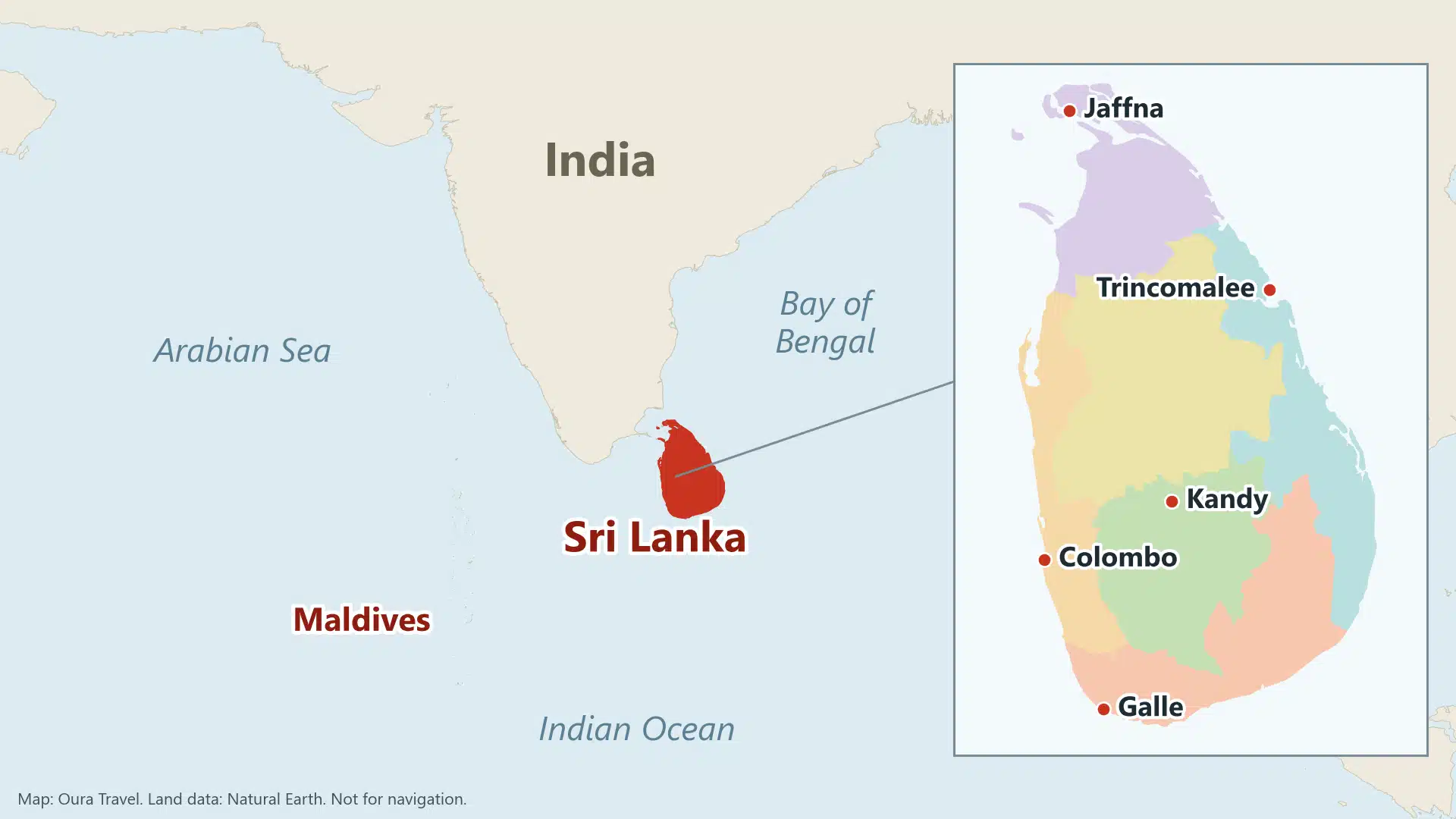
Sri Lanka is an island in the Indian Ocean, off the south-east tip of India, 432 km long and 224 km wide with a total area of about 65,610 sq km (Ministry of Foreign Affairs). The map below marks the main towns, beaches, heritage sites and national parks, and this guide adds the regions and road times you need to turn it into a route. Everything dated here is as it stood when we checked on 31 October 2026.
Key takeaways
- The island runs about 432 km north to south, but that says little about time. Allow 9 hours by road from Colombo airport to Jaffna.
- A first trip can fit in the southern two-thirds of the map: the west and south coasts, the Hill Country and the Cultural Triangle.
- The two monsoons hit opposite sides of the island, so the coast you pick depends on your month.
- Parts of the main railway were suspended in late October 2026, so check before you plan around a line on an older map.
Where is Sri Lanka?
Sri Lanka sits at the junction of the Bay of Bengal and the Arabian Sea, in the words of the Ministry of Foreign Affairs. It lies between 5°55′ and 9°51′ north and between 79°41′ and 81°53′ east, so it is a few degrees above the equator. The clock runs at UTC+5:30, which puts it 5.5 hours ahead of London in winter.
India is the nearest neighbour, across the narrow Palk Strait (WorldAtlas). The Maldives lie to the south-west. Sri Lanka is its own country, the Democratic Socialist Republic of Sri Lanka, and not a part of India.
How big is Sri Lanka, and what is its capital?
The ministry and the Central Bank agree on a total of 65,610 sq km, and the bank splits it into 62,705 sq km of land and 2,905 sq km of inland waters. The coastline figure varies more. The ministry gives about 1,790 km, the National Audit Office about 1,620 km without the lagoons, and one tourist map site 833 miles, or about 1,340 km. Treat any coast length as approximate, because the answer depends on what gets measured. The land rises from coastal plains to central highlands, with the highest point at Pidurutalagala (2,524 m). Those hills are why a short distance on the map can mean a long day on the road. The capital catches people out too. The ministry names Sri Jayawardenepura Kotte as the administrative capital and Colombo as the largest city.
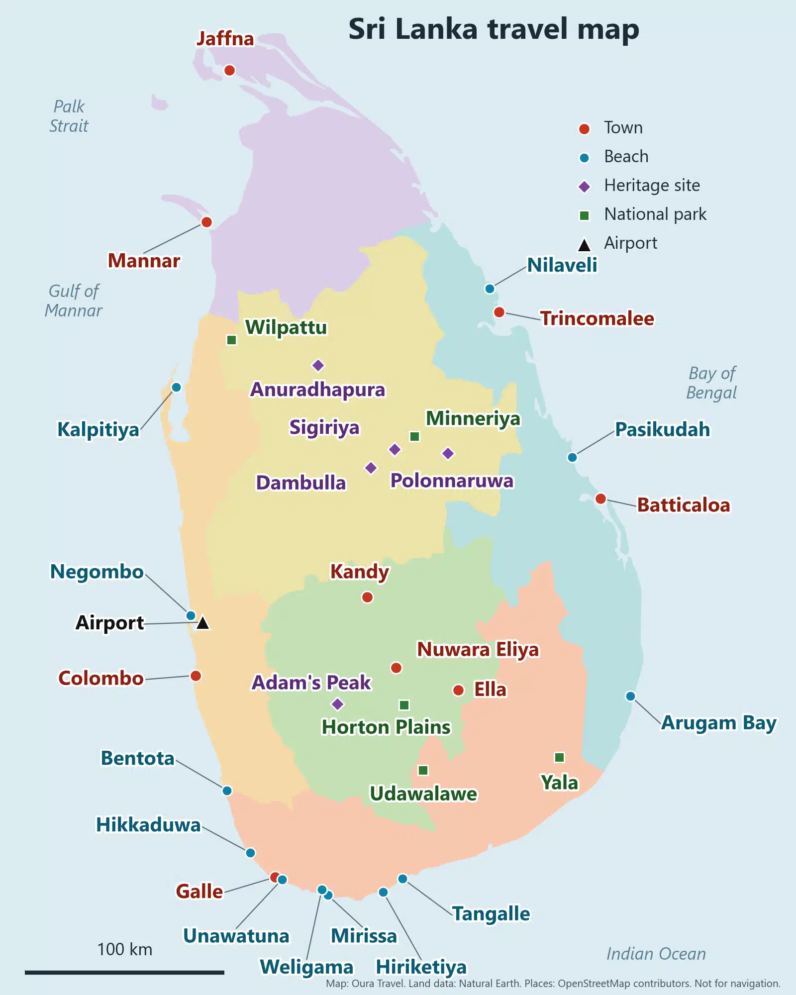
Map of Sri Lanka with cities, beaches and parks
We built this map ourselves for trip planning. Red dots are towns, blue dots are beaches, purple diamonds are heritage sites and green squares are national parks. The black triangle is Bandaranaike International Airport, north of Colombo and close to Negombo.
The colours on the map are our six travel regions. We left roads and rail lines off, so do not navigate with it. Each green square marks the middle of a park as OpenStreetMap places it, not an entrance, and that matters most at Yala, a large park.
For closer maps of single places, use our guides. The Mirissa beach guide and the Unawatuna beach guide cover those bays, and the Kandy to Ella train guide covers the line through the hills. To compare the sand itself, see our best beaches guide.
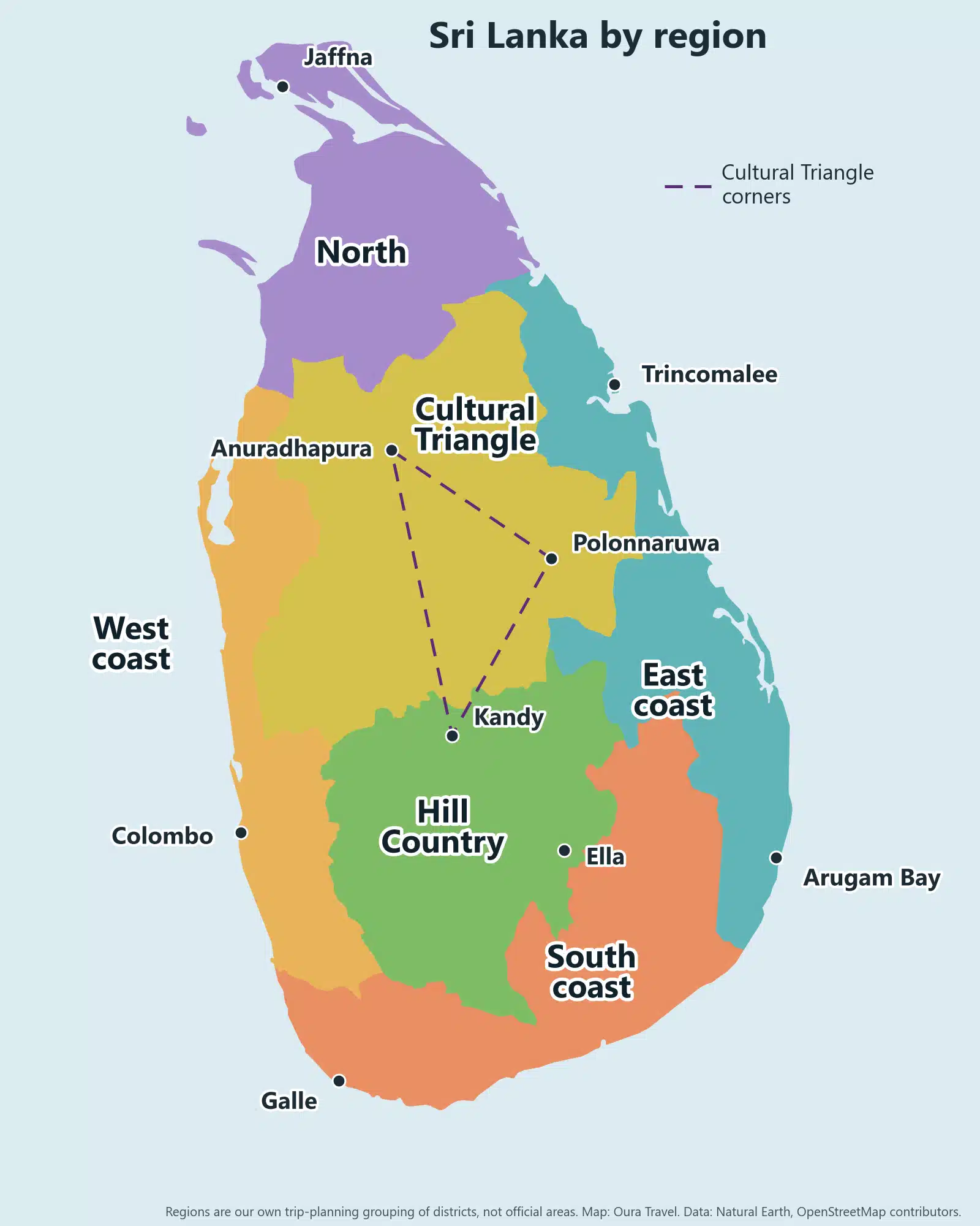
Sri Lanka’s six travel regions
Officially the island has nine provinces. Those lines do not match how people travel, so we grouped the districts into six regions of our own. The borders are ours and approximate. A place near an edge, such as Kandy, Bentota or Wilpattu, could sit on either side.
West coast
Bandaranaike International Airport is here, along with Colombo. Negombo is 11 km from the airport by road. Further north, Kalpitiya sits on its own peninsula, and Love Sri Lanka puts it about 1.5 hours from Wilpattu National Park. For the first drive, see our Colombo airport taxi guide.
South coast
Our colouring starts at Bentota, 109 km from the airport by road and right on the border of this region, and takes in Hikkaduwa on the way down. Galle, Unawatuna, Weligama, Mirissa, Hiriketiya and Tangalle then sit in a line along the southern shore. The old town of Galle and its fort are on the UNESCO list (1988). Love Sri Lanka gives November to April as the whale season at Mirissa and says nothing can be guaranteed. The same colour covers Yala and Udawalawe, two of the national parks behind this coast.
Hill Country
Kandy, Nuwara Eliya, Ella and Adam’s Peak are here, among the tea estates. The Sacred City of Kandy has been on the UNESCO list since 1988 and the Central Highlands since 2010. Horton Plains reaches 6,900 to 7,500 ft, on Love Sri Lanka’s figures, and lies roughly an hour from Nuwara Eliya.
Cultural Triangle
The Cultural Triangle is the area between Anuradhapura, Polonnaruwa and Kandy. Anuradhapura, Polonnaruwa and Sigiriya joined the UNESCO list in 1982, and the Dambulla cave temple followed in 1991. Our map colours the plains around them and leaves Kandy in the Hill Country, which is why the dashed triangle crosses a border. Minneriya, known for its elephant gathering from July to October, sits between Sigiriya and Polonnaruwa.
East coast
The three main stops are far apart. Trincomalee has its natural harbour and the beaches of Nilaveli and Uppuveli just north. Pasikudah, north of Batticaloa, is known for a long shallow reef coast. Arugam Bay lies far to the south and draws surfers. A road trip along this side is a separate plan from the south coast.
North
Jaffna, on the northern tip, is a predominantly Tamil city known for the Nallur Kandaswamy Temple. Mannar lies on the north-west coast. Distance is the catch up here, as the table below shows.
Which side of the map suits which months
The ministry’s calendar has two monsoons: south-west from May, and north-east from December, with inter-monsoon months between them. For a December to February trip, that points you to the west and south, because the north-east monsoon mostly wets the opposite side of the island. In the middle of the year the picture flips, and the east is the drier coast.
We keep the numbers in two places. Use weather by month for rainfall and the monsoon guide for which coast gets what, and when.
Distances in Sri Lanka: drive times from Colombo airport
These are estimates. We ran each route on the OpenStreetMap planner (FOSSGIS car router) on 31 October 2026, and each place name links to its route. The router does not know about traffic, roadworks or landslips, so our last column adds a margin: router time times 1.3, or times 1.5 for Nuwara Eliya and Ella, rounded up to the half hour. That rule is our own.
| To | Road distance | Router time | Allow |
|---|---|---|---|
| Negombo | 11 km | 15 min | 30 min |
| Colombo Fort | 33 km | 29 min | 1 hour |
| Bentota | 109 km | 1 hr 32 | 2 hours |
| Galle | 153 km | 2 hr 2 | 3 hours |
| Mirissa | 176 km | 2 hr 22 | 3.5 hours |
| Tangalle | 211 km | 2 hr 47 | 4 hours |
| Tissamaharama, for Yala | 278 km | 3 hr 42 | 5 hours |
| Kandy | 101 km | 1 hr 59 | 3 hours |
| Nuwara Eliya | 153 km | 2 hr 59 | 4.5 hours |
| Ella | 206 km | 3 hr 51 | 6 hours |
| Dambulla | 128 km | 2 hr 15 | 3 hours |
| Sigiriya | 145 km | 2 hr 37 | 3.5 hours |
| Anuradhapura | 182 km | 3 hr 21 | 4.5 hours |
| Polonnaruwa | 194 km | 3 hr 26 | 4.5 hours |
| Trincomalee | 236 km | 4 hr 19 | 6 hours |
| Pasikudah | 264 km | 4 hr 47 | 6.5 hours |
| Arugam Bay | 319 km | 5 hr 51 | 8 hours |
| Jaffna | 377 km | 6 hr 53 | 9 hours |
Tangalle is 110 km further than Kandy, yet the router puts the two less than an hour apart, because the run south uses the expressway. Inland roads are slower: Ella is closer than Tissamaharama on the road and takes longer.
Check conditions before a long drive. GOV.UK says heavy rainfall in the inter-monsoon season has increased the flood and landslide risk across the country and that transport may be disrupted. That page was updated on 21 September 2026 and was still marked current on 31 October. Its safety page says driving is erratic and accidents are frequent, above all after dark, and that some remote roads may be in poor condition.
Trains in Sri Lanka: rail status in late October 2026
Older maps show a full rail network, and some pages still describe it as if nothing has changed. Cyclone Ditwah stopped the hill lines in late 2025, and trains only returned to Peradeniya and Gampola on 2 October 2026. On 25 October the Department of Railways suspended all services between Rambukkana and Peradeniya and Gampola until further notice (Newswire). A report on 26 October said the Main Line was also suspended between Gampola and Nanu Oya, with trains only from Nanu Oya to Badulla, and that Peradeniya to Matale had stopped. We found no report of a reopening up to 31 October. The railway’s general manager said on 1 October that plans were under way to resume Colombo to Kandy in January. That report gave no timetable, so check with Sri Lanka Railways before you book around it.
Using the map to plan a route
Start with your month and pick the coast that suits it. Then draw a loop from the airport, because you will fly home from the same place unless you book otherwise. One winter shape runs inland to the Cultural Triangle, south through the Hill Country and out to the south coast, then back up the expressway. Trincomalee or Arugam Bay can join that loop, but each adds a long transfer. Jaffna is 9 hours each way on our figures, so it needs extra days. Our own rule of thumb is to keep most drives under 4 hours on the table above.
If you would like a hand turning the map into a route for your dates, contact Oura Travel.
FAQ
Is Sri Lanka part of India?
No. Sri Lanka is an independent island country, the Democratic Socialist Republic of Sri Lanka, separated from India by the Palk Strait.
What is the capital of Sri Lanka?
The Ministry of Foreign Affairs names Sri Jayawardenepura Kotte as the administrative capital. Colombo is the largest city.
How long does it take to drive from the north to the south of Sri Lanka?
Jaffna to Galle is 500 km and 8 hours 32 minutes on the router when we checked on 31 October 2026. By our rule, allow 11.5 hours, so break the trip.
Can you see the south and east coasts on one trip?
Yes, but the two are a long way apart by road. Galle to Arugam Bay is 278 km, 4 hours 27 minutes on the router, so allow 6 hours. The monsoons also favour them in different months, so check both in our weather guide first.
Top map: Sri Lanka’s position in the Indian Ocean. Map: Oura Travel, from Natural Earth data (public domain) and town positions from OpenStreetMap. OpenStreetMap data, used for the map positions and the road table, is available under the Open Database License.